WebGIS-路径规划
·
<!DOCTYPE html>
<html lang="en">

<head>
    <meta charset="UTF-8">
    <meta http-equiv="X-UA-Compatible" content="IE=edge">
    <meta name="viewport" content="width=device-width, initial-scale=1.0">
    <title>智慧校园</title>
    <!-- 引入资源 -->
    <!-- 1 引入CSS资源 -->
    <link rel="stylesheet" href="https://a.amap.com/jsapi_demos/static/demo-center/css/demo-center.css" />
    <link rel="stylesheet" href="./css/index.css">
    <!-- 2 引入JS资源 -->
    <script type="text/javascript">
        window._AMapSecurityConfig = {
            securityJsCode: '自己的',
        }
    </script>
    <script type="text/javascript"
        src="https://webapi.amap.com/maps?v=2.0&key=自己的&plugin=AMap.GeoJSON"></script>
    <script src="./js/store.js"> </script>
</head>

<body>
    <!-- 1 创建地图容器 -->
    <div id="container"></div>
    <div class="info">点击地图标注热门地点</div>
    <div class="input-card" style="width: 10rem;">
        <h4>推荐浏览路线</h4>
        <div class="input-item">
            <button class="btn" onclick="startAnimation()">开始动画</button>
        </div>
    </div>
    <script>
        var map = new AMap.Map('container', {
            center: [114.402672, 30.518987],
            zoom: 16,
            viewMode: '3D',
            pitch: 45
        })
        AMap.plugin(['AMap.ToolBar', 'AMap.Scale', 'AMap.ControlBar','AMap.MoveAnimation',], function () {
            map.addControl(new AMap.ToolBar({
                position:{
                    top:'80px',
                    right:'40px',
                }
            }));
            map.addControl(new AMap.Scale());
            map.addControl(new AMap.ControlBar());
        })

        // 定义一个全局变量,保存geojson
        var geojson=new AMap.GeoJSON({
            geoJSON:null,
        })


         // 如果存在数据,则导出数据
         if(JSON.stringify(getData())!='[]'){
              // 导入数据
            geojson.importData(getData());
            //回复旧数据的点击事件
            geojson.eachOverlay(function(item){
                item.on('click',function(e){
                    // console.log(e.lnglat,'旧的数据点击了');
                    //让点击的marker对象的clcik属性+1
                var ext=item.getExtData()
                // ext._geoJsonProperties.clcik=ext._geoJsonProperties.clcik+1
                // var click=ext._geoJsonProperties.clcik
                var click=++ext._geoJsonProperties.clcik
                // console.log('点击了'+click+'次');

                // 使用消息提示框显示次数
                var infowindow=new AMap.InfoWindow({
                    anchor:'top-center',
                    content:`<div>打卡了${click}次</div>`
                })
                //显示(打开信息窗口)
                infowindow.open(map,item.getPosition());
                saveData(geojson.toGeoJSON())
                })
            })
         }

            map.add(geojson);
            // console.log(geojson);
        // 监听地图点击事件
        map.on('click', function (e) {
            var marker = new AMap.Marker({
                position: e.lnglat,
                extData:{
                    _geoJsonProperties:{
                        gid:geojson.getOverlays().length+1,
                        clcik:0.
                    }
                }
            })
            // 使用覆盖物的点击事件
            marker.on('click',function(e){
                // console.log(e.lnglat,'点击了');
                //让点击的marker对象的clcik属性+1
                var ext=marker.getExtData()
                // ext._geoJsonProperties.clcik=ext._geoJsonProperties.clcik+1
                // var click=ext._geoJsonProperties.clcik
                var click=++ext._geoJsonProperties.clcik
                // console.log('点击了'+click+'次');
                // 使用消息提示框显示次数
                var infowindow=new AMap.InfoWindow({
                    anchor:'top-center',
                    content:`<div>打卡了${click}次</div>`
                })
                //显示(打开信息窗口)
                infowindow.open(map,marker.getPosition());
                saveData(geojson.toGeoJSON())
            })


            // 通过geojson管理覆盖物,显示点
            // map.add(marker);
            geojson.addOverlay(marker);
            // console.log(geojson);
            // 保存数据,将geojson对象转换为标准的GeoJSON格式对象
            saveData(geojson.toGeoJSON())

        })

        function startAnimation(){
            // console.log('开始动画');
            // 实现路径规划
            AMap.plugin('AMap.Driving',function(){
                var driving=new AMap.Driving({
                    map:map,
                    //驾车策略
                    policy:AMap.DrivingPolicy.LEAST_TIME
                })
                //设置起始点
                var start=new AMap.LngLat(114.40099, 30.518649)//东门
                var end=new AMap.LngLat(114.404767, 30.523864)//西北门
                // 通过geojson得到每一个点的坐标
                var opts={
                    waypoints:[],
                }
                geojson.eachOverlay(function(item){
                    // console.log(item);
                    opts.waypoints.push(item.getPosition())
                })

                driving.search(start,end,opts,function(status,result){
                    if(status=='complete'){
                        // console.log('ok');
                        // 实现轨迹模拟
                        // console.log(result);
                        var lineArr=[];

                        result.routes[0].steps.forEach(function(item){
                            lineArr.push(...item.path)
                        })

                        var marker=new AMap.Marker({
                            map:map,
                            position:start,
                            icon:'https://webapi.amap.com/images/car.png',
                            offset:new AMap.Pixel(-26,-13),
                            // autoRoation:true,
                            // angle:-180,

                        })
                        var passedPolyline=new AMap.Polyline({
                            map:map,
                            strokeColor:"#AF5",//线的颜色
                            strokeWeight:6,//线宽

                        })
                        marker.on('moving',function(e){
                            passedPolyline.setPath(e.passedPath)
                        })

                        map.setFitView();

                        marker.moveAlong(lineArr,{
                            duration:500,
                            autoRoation:true,
                        })


                    }else{
                        console.log('error');
                    }

                })
            })
        }


    </script>
</body>

</html>
store.js
// 从localstorage中读取数据
function getData(){
    // 如果本地localstorage中不存在数据
    if(!localStorage.getItem('geojson')){
        localStorage.setItem('geojson','[]')
    }
    return JSON.parse(localStorage.getItem('geojson'))
}
// 将数据保存到localStorage中
function saveData(data){
    localStorage.setItem('geojson',JSON.stringify(data))
}
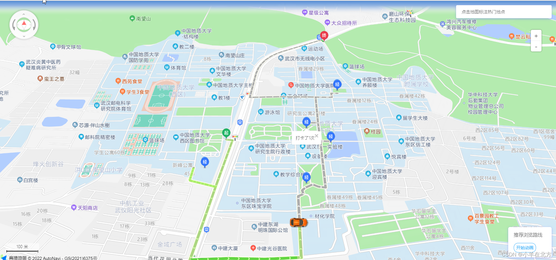
初学者学习记录,勿喷,侵删!

北京人形旗下天工造物具身智能开源社区,聚焦具身天工与慧思开物两大平台
更多推荐
 2
2 0
0- 0


 已为社区贡献1条内容

所有评论(0)